Background
West Yorkshire Combined Authority (Combined Authority) was established in 2014, combining the 10 districts of Barnsley, Bradford, Calderdale, Craven, Harrogate, Kirklees, Leeds, Selby, Wakefield and York – a 5,700km2 area known collectively as Leeds City Region. It is a strategic authority with governance over transport, economic development and regeneration. The Combined Authority also operate the Metro network of bus stations, travel centres and public transport information in West Yorkshire.
The Problem
With six service changes for bus and rail each year, the task of keeping travel information up to date has not been simple. The public transport team at the Combined Authority needed an effective way of managing updates to over 100 onward travel posters across the region. The Combined Authorities existing solution was provided as a customisation to ArcGIS which had become vulnerable to wider IT upgrades. While it allowed the team to create a variety of poster products showing maps and bus information, additional functionality was identified by the team in order to provide a more intuitive and adaptable system.
The Requirement
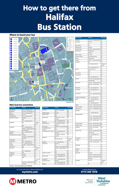
The Combined Authority decided to replace their existing system, taking the opportunity to add a number of enhancements. The purpose of the proposed new system was to enable the team at the Combined Authority to create maps showing 'where to board your bus' with an accompanying table displaying destinations, service numbers and bus stops.
As the Combined Authorities existing solution was hosted internally and had become difficult to manage, their preference was for a hosted, cloud-based solution with an easy-to-use, intuitive interface. The requirement was for a system able to generate a number of different templates which could be printed as hard copy posters for display at key transport interchanges and other locations. The location of all bus stops and localities would be provided via a NaPTAN data feed, and services and destinations via a TransXChange data feed.
The specification included a requirement for mapping of the whole the Combined Authority area at 1:2500, combined with a 'live map features' tool, that would allow users to add icons to the base mapping which would be saved for use when the poster was updated.
The Solution
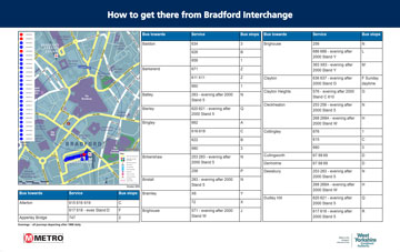
Pindar Creative proposed using their existing OLWIN (Onward Localised Wayside Information Notices) solution, with some modifications, customised to the Combined Authorities specific requirements. OLWIN is a tool to identify all bus stops within a specified radius of a hub and automatically generate destination information required for onward travel and wayfinding posters. Once new TransXChange data imports are carried out, the inbuilt reporting system will indicate which posters need to be updated based upon agreed business logic. The Combined Authority commissioned us to deliver the new solution within three months of the project start date.
For the mapping element we created a new, seamless cartographic base covering the whole area. Designed with legibility in mind, the base map would act as a backdrop, enabling the team at the Combined Authority to add additional information where required. We took the opportunity to update the mapping style to reflect the ‘Legible Leeds’ branding, which is widely recognised in the area.
The user interface allows the team at the Combined Authority to add icons and/or labels and to move or delete any number of additional features to the base mapping, such as cycle parking, taxi ranks, points of interest and stand-alone text labels. The north arrow and legend can both be moved to the most appropriate part of the map and an isochrone representing a five-minute walk from the location is automatically added to each map.
OLWIN identifies all bus stops within a specified radius of a hub and automatically generates destination information required for onward travel and wayfinding posters. The system comprises pre-determined templates that enable large format posters to be created, showing ‘where to board your bus’ maps combined with tables listing services and destinations from the selected bus stops. As new TransXChange data imports are carried out by the end user, the system indicates which posters need to be updated.
OLWN allows the user to select a specific area where all the bus stops will be plotted into the map. Users can:
- choose to include or omit bus stops
- edit stop name/letter
- choose the template
- edit header/footer
- exclude services/destinations from the poster