The Challenge - Create a flexible base map showing sustainable modes of travel, which can be used to create a wide range of printed leaflets and online solutions.
Buckinghamshire County Council has published a variety of maps to promote sustainable travel, but due to reduced resources and budgets the sustainable travel team were keen to move to a solution which streamlined the production of future mapping products.
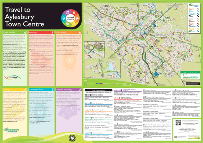
the solution
Pindar Creative has mapped the county of Buckinghamshire using GIS data in a user friendly style. The base map shows all sustainable modes of travel including cycle, train and bus routes. This base map is very flexible and can be used for a wide range of products including printed maps, leaflets and online solutions.
The range of printed publications are available in varying sizes from pocket maps to A1 wallcharts. These provide a consistent style and format for all their communications saving them time and money.
All leaflets and posters can be ordered on-line, ensuring consistency of the communication, reduced administration costs through improved workflows.
interactive websites showing onward journeys
A wide range of interactive solutions are also available to end users in the area including, interactive mapping websites, and mobile optimised sites.
The website templates can include:
- An Interactive map with pan-around functionality
- Clickable hotspots
- Links to other websites (journey planners)
- Links to real-time information (e.g. live departure boards)
This can be incorporated into a website or sent as a link via email.
Read more about Sustainable Travel Solutions.
Read more about Travel Plans.